In the province of Turin, a significant environmental transformation is underway, led by RSA (Society for Environmental Remediation and Development), at the former asbestos mines of Balangero and Corio. Designated as a Site of National Interest (SIN), this site presents a unique challenge for environmental remediation and protection. In this endeavor, Pangea Cloud and GeneGIS services play a pivotal role in accelerating digital transformation and supporting the management of ongoing site monitoring plans.

In 2022, RSA embarked on an advanced digitalization project to enhance ongoing remediation monitoring plans. The primary objective of this initiative was and remains to gather high-resolution digital data to provide a comprehensive overview for the accurate assessment of environmental and infrastructural conditions in the area, as well as to analyze the AS IS and TO BE design aspects thoroughly.


The substantial volume of data collected, including aerial surveys, laser scanning, immersive 360° facility inspections, and more, from this project has been and continues to be extensive. This necessitated an advanced platform for managing and analyzing this information swiftly and intuitively, both internally and externally. To meet this challenge, GeneGIS and RSA entered into an agreement. The Pangea Cloud platform was chosen to complement the project, providing RSA with an end-to-end solution for cloud-based collection and analysis of monitoring plans and planning activities for new interventions in complex environmental and infrastructural contexts.
 
Pangea Cloud facilitates the seamless integration of data sourced from multiple channels, including aircraft, drones, and satellites, with the wealth of information available on-site, including preliminary projects and historical archives. This repository encompasses documentation, photos, and video inspections, serving as a fundamental operational tool for all management and design activities within the former asbestos mine area.
 

Among our services, we offer:

Digital Cartography Harmonization: Through OGC services, access high-quality digital maps from regional and national geoportals.

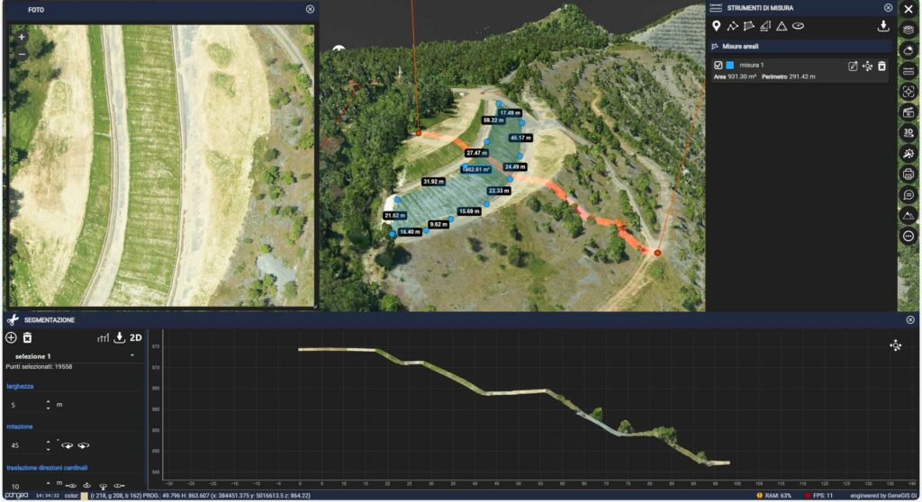
Provision of Orthophotos and 3D Point Clouds: Detailed multidimensional representations of the environment and facilities.

360° Immersive Inspections: Provide valuable qualitative and quantitative information on facility conditions for detailed revisits and analyses in complex sites safely.

Geo-Referenced Technical Documentation: Critical documentation for management and maintenance by cataloging inspection plans.

 
The RSA project focuses on several key activities, including:
 

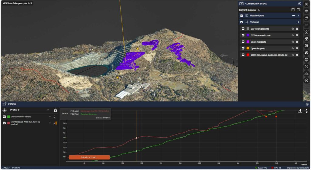
Multi-temporal Remote Sensing of the site.

Execution of on-demand flights for specific interventions and delivery of 2D/3D photogrammetric products.

Analysis of data from new airborne sensing technologies.

Historical data analysis to understand territorial evolution.

Implementation of an advanced system for the collection, harmonization, visualization, querying, and sharing of existing information assets.

The data provided by the Pangea Cloud platform is diverse and covers a wide range of information, from environmental analysis to industrial architecture and weather conditions. This wealth of data offers a comprehensive overview of the area and its conditions, enabling RSA to make informed decisions and optimize management activities.


In conclusion, the RSA project and the Pangea Cloud platform represent a significant step towards the sustainable management of the former asbestos mines of Balangero and Corio. This project demonstrates how technology and innovation can play a crucial role in ensuring environmental protection in complex contexts, opening up new opportunities for the remediation and sustainable development of nationally significant sites like this one.

The data provided by the Pangea Cloud platform includes: 

  • Environmental and Architectural Laser Scanner Surveys of the restoration area 
  • Satellite imagery 
  • Aerial photogrammetry 
  • Documents and technical specifications 
  • 360° photos 
  • Ground and drone-captured videos 
  • Weather data 
  • Video data captured by streaming cameras 
  • GBInSAR and InSAR interferometric data from satellites, with real-time analysis compared to temperature trends in the surrounding environment, and much more.