An island of extraordinary beauty yet highly vulnerable, Ischia grapples with its geology prone to landslides. Compounded by rampant illegal construction and neglect in land maintenance, the challenges mount. Moreover, climate change exacerbates the severity of weather conditions, subjecting this enchanting island to relentless trials.

Project Description:

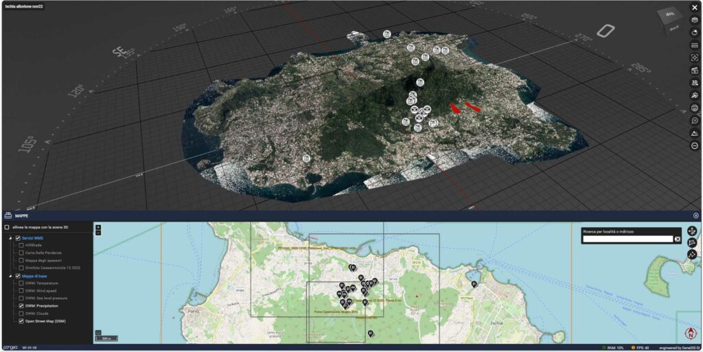
During the night of November 25th to 26th, 2022, the Campanian island experienced yet another tragic natural disaster. Over a span of six hours, a record-breaking 126 mm of rainfall was recorded, indicating the severity of the downpour.

The heavy rains triggered several slope phenomena across the island, but the most devastating was a landslide originating from Mount Epomeo, which swept towards the sea, severely impacting the municipality of Casamicciola Terme. Homes, roads, and vehicles were engulfed by a torrent of mud and soil, resulting in devastating loss of life.

In this context, a Pangea Cloud license was swiftly activated and provided with support to centralize all historical and current data, including drone inspections, LiDAR surveys, and satellite imagery, stemming from monitoring efforts on the island. This data was then distributed, based on differentiated privileges, to all stakeholders involved in emergency operations.

This support activity continues throughout the reconstruction phase, aiding in monitoring and census activities to bolster the new intervention plan. The key value addition lies in the immediate accessibility of all necessary data to technicians and decision-makers, facilitating the representation of work progress, identification of any critical issues, and seamless access to associated documentation for planned and ongoing activities.

The data provided by the Pangea Cloud platform includes: 

  • Environmental and Architectural Laser Scanner Surveys of the restoration area 
  • Satellite imagery 
  • Aerial photogrammetry 
  • Documents and technical specifications 
  • 360° photos 
  • Ground and drone-captured videos 
  • Weather data 
  • Video data captured by streaming cameras 
  • GBInSAR and InSAR interferometric data from satellites, with real-time analysis compared to temperature trends in the surrounding environment, and much more.